Avalanche forecasters from Chamonix, Bourg Saint Maurice and the Southern Alps have been out in the field getting beta for the Meteo France bulletins. This is a summary of what they found.
Col de Bostan (Chamonix, February 24, 2025)
A recent field survey conducted by Météo-France Chamonix at Col de Bostan (2300m) provided valuable insight into the current snowpack stability and avalanche risks in the Haut-Giffre region.
Snow Conditions:
-
Below 2100m, the snow was wet, with only a thin layer of cold snow present above this altitude.
-
On ridge lines, wind effects were significant, forming small wind slabs that cracked under skis but showed no propagation and were relatively thin.
-
The descent into the bowl had less wind influence, with approximately 2 cm of fresh, light snow above 2100m.
Avalanche Activity:
-
Reports from the Golèse refuge indicated 2-3 glide avalanches observed the previous day.
-
Unusual for the season, glide avalanches were triggered even on north-facing slopes.
Snowpack Analysis:
-
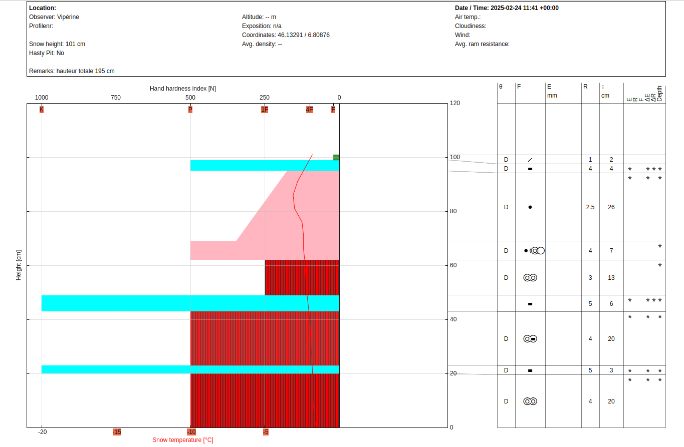
A snow profile conducted at 2300m in a southwest-facing location revealed a 195 cm snowpack.
-
The surface layer consisted of 2 cm of fresh snow over a 5 cm crust, followed by 30-35 cm of well-cohesive fine-grain snow.
-
Below this, alternating crusts and rounded grains indicated past moisture infiltration.
-
A compression test (CT) showed no weak layers, indicating general stability.
-
In wind-affected areas, shallow cracks in the top 2-5 cm were observed, but no propagation was seen.
www.facebook.com/groups/meteofrancealpesdunord
Becca Motta (Bourg St. Maurice, February 24, 2025)
Météo-France Bourg St. Maurice performed an assessment at Becca Motta (2700m) to evaluate snow conditions and potential avalanche risks.
Snow Conditions:
-
Below 1800m: poor-quality, wet snow.
-
Between 1800m and 2000m: a mix of sticky and crusty snow depending on aspect.
-
Above 2000m: significant variation by aspect—southern slopes showed progressive spring-like conditions, while northern slopes retained good-quality, cold snow in a fresh surface layer.
Avalanche Activity:
-
No major activity reported, but surface sluffing occurred below 2000m, especially under 1800m.
-
Persistent weak layers were found at the base of the snowpack in north-facing terrain at 2700m, but they were currently inactive due to a dense 150cm fine-grain snow layer above.
-
The recent snowfall from Sunday remains dry in north-facing aspects and could act as a temporary weak layer for the anticipated 15-20 cm of fresh snow expected the following day.
https://skitour.fr/sorties/177669
Écrins (Southern Alps, February 18, 2025)
A high-altitude snow profile was conducted in the Écrins massif to assess persistent weak layers and their potential activation.
Snow Conditions:
-
At 2800m in a northeast-facing slope, a total snow depth of 210 cm was recorded.
-
The surface consisted of 15 cm of dry snow with recognizable particles and faceted crystals.
-
Below this, a thick layer of increasingly dense fine-grain snow was present.
-
At the base, a 40-50 cm layer of angular grains was found but was well-compacted.
Avalanche Activity & Stability:
-
Small wind slabs formed on February 16 due to strong northern winds but were breaking down due to clear nights.
-
These slabs were never highly reactive, as their weak layer consisted mainly of recognizable snow particles rather than a well-developed weak layer.
-
The deep angular grains at the base of the snowpack appeared unreactive due to the significant snow depth in the area.
-
However, caution is advised in thinner snowpack zones, such as ridge edges and couloirs, where weak layers may still be more easily triggered.
https://skitour.fr/sorties/177407
Overall Summary of Avalanche Conditions
Across the surveyed regions, the snowpack showed generally stable conditions above 2000m, with localized concerns in wind-affected areas and specific aspects. Key takeaways include:
-
Shallow wind slabs on ridges in Chamonix and the Écrins were present but mostly non-propagating.
-
Glide avalanches were observed, even on atypical north-facing slopes in Haut-Giffre.
-
Persistent weak layers at the base of the snowpack exist in the northern aspects of Becca Motta and Écrins but remain largely inactive due to depth and overlying dense layers.
-
Upcoming snowfall could temporarily increase instability in shaded slopes where the recent snow remains unconsolidated.
Current conditions indicate relative stability in most areas, continued monitoring is necessary, particularly with forecasted new snow and potential reactivation of weak layers in thinner snowpack regions.